You are here

prints

Advanced SCOS-2000 monitoring

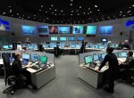
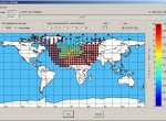
The aim of the SCOS-2000 Advanced Monitoring project was to verify latest technologies for monitoring and visualization of telemetry data and commands in the satellite system SCOS-2000. The project also addressed the application of the resulting analysis and prototypes in the context of a new European Ground Operation Software architecture (EGOS).

Proba-2 TPMU

An instrument for measuring thermal plasma in space TMPU was designed and developer at the Institute of Atmospheric Physics AS CR. The flight model was manufactured also by the company Czech Space Research Centre (CSRC) in Brno. The device will capture scientific data for research of thermal plasma in the vicinity of the Earth.

PROBA-2 DSLP

The Dual Segmented Langmuir Probe (DSLP) is one of the four scientific experiments on board the ESA satellite Proba-2. The DSLP instrument has been developed and manufactured in the Czech Republic by a scientific-industrial consortium.

IIM-TS

Project Image IIM-TS has extended the capabilities of system for satellite images analysis (KEO - Knowledge-centered Earth Observation), which is carried out at the ESA ESRIN, by comparision of images in the time sequence. These methods are useful particulary for the change detection.

SISNeT

Signal in Space through the Internet (SISNeT) is name of technology that disseminates accurate navigation data from EGNOS system through the Internet. A new-generation data server which is the main pillar of the services has been developed, as well as the software called SBAS TeACHER who serves as a tool for SBAS messages editing.

EGNOS Edutools

The main objectives of the project were development of educational programmes, which nowadays help to easily understand EGNOS system and its principles and also functioning GNSS systems in general.

GSE LAND

GSE Land is a project of Europian satellite monitoring, which is preparing the conditions for the operation of GMES Land Monitoring Core Service. The output map products are based on a combination of satellite imagery and other auxiliary data. The outputs are used for example in agriculture and soil protection or urban planning.

Pages

Subscribe to RSS - prints